| Timbering in 2007
|
|||||||||
| |
Hey,
I took the archaeology club to Brown's Mount today. Guess
what? It has been
timbered! Either the DNR or the Fish & Wildlife timbered
the top of Brown's
Mount, probably about three months ago. They cut the pines,
probably because
of pine beetles. When a logging operation starts, they come
in with a
bulldozer and clear a loading area for the loader machine to
load the trees
onto the trucks. The loading area is on top of the 1960's
excavation of the
square earthlodge site, so I assume it got bulldozed. You
can't see if for
the tree tops and limbs laying on the ground. They drove on
top of Little
Mound (on the summit) and cut three trees off of it. Parts
of the ridge
trail along the western cliffs are blocked by fallen trees
and it has been
timbered right up to the edge of it. I have attached a map
that shows the
logged area. I didn't walk along the eastern side, so my map
may not be
entirely accurate. The State owns the land and the Fish
& Wildlife operates
it under a long term lease. I had just heard that they were
going to open it
to the public this month.
Who wants to go see a logging area? It pisses me off to have
worked so hard
and then seen it sit dormant for a decade and then to have
the State or DNR
timber it and set back its tourism/recreational potential
another decade or
more. I am sure there is no landscaping plan to restore the
damage. I
believe they did not know where the square earthlodge was
and probably not
Little Mound.
This is not a Wildlife Management Area, it is supposed to be
a public park.
I imagine they didn't get a land disturbing permit and they
may be exempt
from it.
I will call the Fish & Wildlife tomorrow and ask for
details. Don't do
anything right now, except go out to see Brown's Mount, to
see what you
think of it.
I hate the damage, but I think this can and should be turned
to symbolize
the need to transfer this land to the National Park Service
or the Muscogee
Nation. I think we need to make a big deal in the media
about how bad this
is. How can we save anything if this is how it is
treated? I wish we didn't
have to point out how bad the DNR or Fish & Wildlife is
because that hurts
our cause, but it should be pointed out. They closed Stone
Creek to canoeing
for invalid reasons pertaining to deceleration lanes, but
the parking lot
could not hold the number of cars that would be needed to
justify a
deceleration lane. This shows how ludicrous it is to manage
Bond Swamp from
40 miles away. They are also planning to timber parts of the
Bond Swamp
Refuge. I would like to see their plans now. It shows
tremendous
insensitivity to the Native American significance and
archaeological
significance of Brown's Mount, as well as the tourism
potential. From
bulldozing the Simmon's house to building a parking lot,
bathrooms and a
pavilion 1/4 mile away from Brown's Mount to opening it only
on the weekends
for guided tours to timbering it, what has gone right?
The Monument is doing a study on expanding the Monument's
boundaries. Now is
the time to promote outrage at this action and to promote
its inclusion as
part of the Monument or, if the Muscogee's will push for it,
for Muscogee
ownership of Brown's Mount.
I want to find out the details first and then spread the
word to select
people and get everyone on the same page about a strategy to
get Brown's
Mount out of the Fish & Wildlife's hands. This could
also impact the EPE by
raising the attention level of the public about the
destruction of
significant Native American sites.
So, I'll write back tomorrow.
Also, my email went down a few days ago, so if anyone sent
me anything in
the last 5 days, please resend it.
John
Hey, the DNR did it. I talked to the Forestry guy and he
didn't know
anything about Brown's Mount, except it had beetles, so they
timbered it.
They were debating whether to do anything else, like plant
pines or
hardwoods there or clear the areas with a bushhog or burn
the logged areas.
Haven't read any emails yet, but will when I get back.
Gotta go
Later,
John
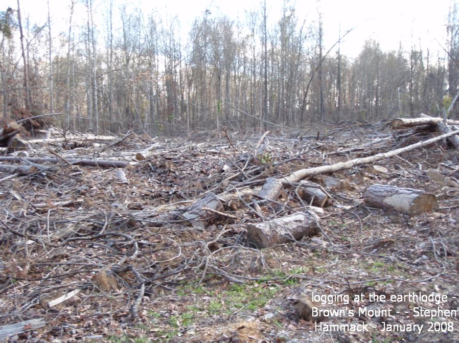
Hello,
Please forward this email and express your opinions.
I walked up Brown's Mount this weekend and was shocked to
find that much of
the summit had been timbered. The loading area was located
right over the
site of the square Earthlodge, which was excavated in the
1960's. The
trenches were still clearly visible prior to logging. The
debris was too
thick to confirm that the site had been bulldozed, but the
loading area is
normally bulldozed to allow the loading equipment and trucks
to move in. The
(heavy) cutting machine also drove on top of the unexcavated
Little Mound
and cut three trees off of it. The scenic "ridge trail" has
trees blocking
it in places. They also timbered right up to the trail in
places, which has
greatly diminished its scenic beauty and will lead to dense,
unsightly
undergrowth. The falling pines, as well as the skidding of
them, damaged
many hardwood trees.
WHO DID THIS?
I just found out about this, but in June 2007, the U.S. Fish
& Wildlife
noticed pine beetle-killed pines on top of Brown's Mount, so
they reported
it to the Ga. DNR and they hired a logger to cut the pines
off of 26 acres.
I called Carl Smitt, the DNR's forestry person in Social
Circle, Ga., whom
was involved in the Brown's Mount timbering. He didn't know
anything about
the archaeological significance of Brown's Mount.
PREHISTORIC BACKGROUND
As a brief background, Brown's Mount is a major
Mississippian site, related
to the Ocmulgee National Monument. A stone wall and ditches
once encircled
the entire summit and is thought to have been constructed in
Woodland times.
An Earthlodge, almost identical to the one at Ocmulgee, was
excavated during
the 1930's and the Mount was recommended for inclusion into
the National
Monument. Little Mound sits on the summit and has not been
excavated. The
square ear lodge is on the summit and was excavated in the
1960's. Myrtle's
Mound is on the side of the Mount and has a looter's pit in
it's center.
Another small mound, near Myrtle's mound was bulldozed
thirty years ago. The
whole top of Brown's Mount is considered an archaeological
site and I assume
it is national register eligible.
BACKGROUND OF PRESERVATION EFFORTS
Brown's Mounts' geological and scenic attributes and
adjacency to the Bond
Swamp National Wildlife Refuge, just 6 minutes from downtown
Macon, make it
an ideal candidate for use as a public park. The Brown's
Mount Association
worked for three years to acquire and preserve the Mount.
The Tourism
Development Commission of Macon & Middle Georgia made
preserving the Mount a
top 5 priority and the Macon-Bibb Industrial Authority paid
$10,000 for a
purchase option to forestall development till funding could
be raised. The
Peyton Anderson Foundation purchased the property and gave
it to the Museum
of Arts & Sciences to manage. Later the State of Georgia
purchased the Mount
and in July 2006, the DNR signed a long-term management
agreement with the
U.S. Fish & Wildlife to manage the Mount. The Mount has
been closed to the
public since its purchase over a decade ago, except for
guided weekend
tours, once a month. The Fish & Wildlife is planning to
open the Mount to
the public soon, possibly later this month.
WHO IN AUTHORITY KNOWS WHERE THE SITES ARE?
US Fish & Wildlife - Carolyn Rogers, assistant refuge
manager at Piedmont
NWR (in charge of Bond Swamp NWR) said in a recent email
concerning the
logging to Sylvia Flowers that:
"If you ever get the itch to show the refuge where some of
these important
> sites are please let me know. I have some
published articles and a few
> bad
> maps. The new refuge manager has been trying to
locate some of the
> documented sites. The regional FWS archeologist
has all the locations but
> we haven't been able to get him to the refuge since we
got management
> control.
GA DNR - Carl Smitt, of DNR Forestry in the Social Circle
office
(706-557-3035), who was involved in the timbering, didn't
have any personal
knowledge of Brown's Mount or its archaeological
significance. Kevin Kramer
is the DNR chief for this region (478-825-6354).
WHO SHOULD OWN AND MANAGE BROWN'S MOUNT?
The Ocmulgee National Monument should own and manage Brown's
Mount and they
are currently conducting a study on expanding their
boundaries. They already
are authorized to almost triple their size to 2,000 acres,
which could
include Brown's Mount, as was originally planned. The Macon
Chamber of
Commerce and Tourism and Visitor's Bureau support the
expansion and
redesignation of the Ocmulgee National Monument to National
Park status. The
DNR has no interest in managing the property. The Fish &
Wildlife has owned
part of Brown's Mount since its creation in about 1989 and
they have been
negotiating a management agreement for the DNR's portion for
many years
prior to the actual signing 1-1/2 years ago. Brown's Mount
should not suffer
from the absentee management of the Piedmont NWR some forty
miles away. If
they do not know where the individual sites are by now, then
they have no
interest in presenting the cultural significance of the
Mount. Brown's Mount
is important because of its Native American significance -
period. It's
scenic views and rocky cliffs give it recreational appeal,
but its wildlife
values do not distinguish it from a dozen other hills within
ten miles. The
Fish and Wildlife is simply not the appropriate agency to
protect, interpret
and promote this truly unique and important place. The
Muscogee Nation would
be another candidate for ownership and management.
WHAT SHOULD HAVE BEEN DONE?
First, the agencies in charge should have learned the value
of what they are
in charge of protecting.
They should have marked the archaeological sites.
They should have hired a landscape architect to develop a
site plan for the
creation of trails and the management of open and forested
areas, instead of
letting the loggers driving the cutter and skidders machines
make all the
decisions. Telling a logger to cut all the pines is not a
landscape plan.
Logging can be conducted in ways which minimize damage to
the remaining
hardwoods, but it requires planning, effort and oversight.
This was not
done.
WHY DID THIS HAPPEN?
This happened because Brown's Mount was not open to the
public.
1. When the Museum of Arts & Sciences owned the
property, they didn't know
what to do and they came to view the Mount as a fragile
ecosystem, whose old
fields, undergrowth and old growth represented a teaching
laboratory and
whose clear skies were an observatory. They blocked off the
gate, so people
couldn't drive up the road to the top of Brown's Mount.
Then, they closed
Brown's Mount road, so there was no public access from the
main road,
Ocmulgee East Blvd. They built a new access road off of a
secondary road.
Then, they built a new parking lot 1/3rd of a mile from the
old, existing
parking lot at the base of Brown's Mount. [How many
businesses would survive
or homes would sell if their parking lot was 1/3rd of a mile
away?] Then,
instead of using either of the two existing houses as
visitor's centers,
they built bathrooms next to the new parking lot. So, if a
visitor on the
Mount had to use the restroom, they would have to walk 1/2
mile back to
their car to use one. An old person would most likely just
leave and a
mother would have to walk back with their kids, so they
could use the
restroom. [What business has bathrooms 1/2 mile away?] They
also built a
pavilion, but it was only 1/4 mile from the base of Brown's
Mount. That was
the facilities. As for operation, the Museum restricted
visitation to guided
weekend trips at specified times, for $5 each person. They
also taught
orienteering on some of these trips. [How many businesses
could survive if
they required their customers to show up at one specified
time, once a week
and possibly once a month?]
2. The Ga. DNR purchased the property and I heard the money
was to fund a
permanent Museum position to keep leading tours to Brown's
Mount. I am not
sure whether that happened or not, but I have not heard of
any significant
activity and the Museum is not sending you this email.
When the DNR took over, the Museum's staff person moved out
of the house at
Brown's Mount and the DNR let the houses deteriorate under
leaking roofs and
then bulldozed them. Mrs. Simmons, the original owner, did
have a well-kept
house and a beautiful yard, full of flowers.
3. The U.S. Fish & Wildlife assumed control and
announced they would be
opening Brown's Mount to the public a year ago, but didn't.
They say they
are going to open it soon, maybe even this month.
SUMMARY
In summary, a more concerted effort to keep people away from
Brown's Mount
could not have been devised. People do whatever is
convenient and businesses
thrive by offering convenience to their customers. We cannot
build a case
for preserving natural areas or significant Native American
sites if the
public cannot enjoy what has already been preserved. If we
inject roadblocks
to the outdoor experience, people will watch television,
work on their
computer, go to the Mall, or partake in an unlimited array
of experiences
that are being pushed their way. If access is denied, there
will be no
awareness or appreciation or concern about these special
places. Brown's
Mount is an awesome asset, with a tremendous potential to
enhance Macon's
quality of life, as a recreational, educational and tourism
attraction. The
problem is that the Fish & Wildlife and the DNR are not
recognizing and
promoting the greatest values of Brown's Mount and Macon is
suffering from
it. Whatever money the DNR made will be offset by even
greater cleanup costs
and decades of lost tree growth.
NO CANOEING IN BOND SWAMP
by far, the best way to experience Bond Swamp is to canoe
Stone Creek. The
Fish & Wildlife used to allow group canoeing trips, but
they have prohibited
that for many years now. They say they need a deceleration
lane off Ocmulgee
East Blvd. (I think it costs $150,000)and a concrete canoe
ramp and to
resolve a property dispute with a downstream landowner.
1. According to DOT guidelines, a deceleration lane is not
required if less
than 50 [and possibly less than 100] vehicles per day turn
into either
Brown's Mount or Bond Swamp per day. The Bond Swamp parking
lot would
probably only hold 30 vehicles and most days there are none
to two cars
there. Brown's Mount would be deemed a tremendous success if
50 cars visited
it a day or a weekend or even in a week's time. Waiting for
funding to build
a $150,000 lane is not a valid excuse.
2. A concrete canoe ramp is not needed because the bank
gradually slopes to
the water. Launching canoes has never been a problem in the
past. The Fish &
Wildlife allows hunters to canoe in Stone Creek during the
refuge hunts, but
does not allow the non-hunting visitor. Carrying a gun does
not make a
better paddler. If a hunter can launch a canoe without a
concrete canoe
ramp, why shouldn't a bird watcher be able to do it?
3. The property dispute, which blocks canoeing on Stone
Creek, is located
2.3 miles downstream of the put-in point. Canoeists have
plenty of stream to
canoe down and back up. Since this is a swamp creek, there
is no current to
handicap upstream paddling.
SUMMARY
Both Bond Swamp NW Refuge and Brown's Mount are vastly
under-utilized and
are subsequently under-appreciated. I spent many years
working to preserve
both these places and I have tried to hold back from
criticizing their
management, but this last episode is pure idiocy. Years
after their
preservation, I should not walk up to Brown's Mount (past a
locked gate) and
find Native American sites desecrated by the paid people in
charge of their
preservation. The fact that this destruction occurred almost
half a year ago
and I was the first person in all that time to recognize
what had occurred
and how utterly senseless and wasteful it was is outrageous.
Please open
these public lands to the public for their convenient use
and enjoyment.
People are needed to protect land and more land needs to be
protected.
Please voice your concerns and opinions.
Thanks,
John Wilson
At 12:53 PM 1/8/2008, David Crass wrote: Hello--I'm not sure from this email what is transpiring. Can you fill me in? Please copy all as my Staff Archaeologist is on this list now, |
|
|||||||
|