| Archaeology |
||
| |
A PROPOSAL TO PERFORM AN ARCHEOLOGICAL INVESTIGATION OF BROWN’S MOUNT, BIBB COUNTY, GEORGIA
Larry R. Abbott
INTRODUCTION
Brown’s Mount is an important archeological resource that has yielded significant information about the past occupants of central Georgia. Yet despite the major archeological investigations of 1934-35 and 1959-60, and the minor investigations of 1989 and 1991, the area has not been subjected to a thorough archeological survey to inventory and document its cultural resources.
Because funds are quite limited for such a project, it is proposed that the survey be done in conjunction with a public archeological training program. The Ocmulgee National Monument Archeologist will give the volunteers explicit field and laboratory training with respect to methodology, observation, and recording, and supervise the field survey and laboratory work. The Archeologist will keep records The Museum shall be expected to provide some financial support for the permanent datums and the land survey, various materials, supplies such as (but not limited to): field and laboratory forms, artifact bags, and curatorial and archival materials.
BACKGROUND
Williams (1993) wrote a thorough review of the history and previous archeological investigations, including his own limited investigations, at Brown’s Mount. This report has provided the information presented in this brief background overview. The first archeological investigations at the Brown’s Mount site (9Bi5), consisting of a surface collection, were conducted by Arthur R. Kelly in 1934. In 1935 Kelly directed formal excavations at Brown’s Mount as part of the WPA excavations in the Macon-Bibb County area. Most of the excavations (Excavation Unit A, Trenches 1-6 and 1A-6A) were long, four-foot wide trenches with some branched connecting trenches and block excavations. Williams (1993) notes that no obvious surface features were present to guide the placement of most of these trenches, suggesting they were exploratory in nature. The trenches were typically dug to a depth of 1 to 2 feet and usually without regard to the soil stratigraphy. However, apparently three sections of trenches were deepened to nearly six feet to expose the soil stratigraphy. Two other trenches (Excavation Units B and C) were apparently dug to intercept surface undulations, one being a shallow basin and the other a small earthen mound. These excavations encountered a number of features including the mound, an number of subsurface basins. Excavation Unit D, placed over a low, freshly plowed, circular rise, exposed the famous “Council Chamber” found at Brown’s Mount. All of the features encountered during these excavations were assigned to the Macon Plateau era of occupation.
During 1959 and 1960 the Macon Archaeological Society, under the direction of Richard Marshall and John Walker, excavated a group of overlapping earth-covered structures at Brown’s Mount (Marshal 1971; Salter 1960). The excavation found two entrances, and stratigraphic evidence suggested that this was an earth-covered structure superimposed over an earlier similar structure. Charcoal from the hearth was radiocarbon dated to 970 B.P. ± 150, or about AD 980. The radiocarbon date and the artifacts indicate “the complex group of structures is closely related to the Macon Plateau occupation …” (Williams 1993:68).
Williams (1993:69) spent two field days on the site with the Mercer University crew and succeeded in excavating two 2 m x 2 m units, each to a depth of 30 cm. One unit was dug east of the small mound at the site where the eastern end of Kelly’s Trench 1C was encountered. The other unit was dug in a field (apparently off the Museum’s property) in the vicinity of Kelly’s “Council Chamber” but no evidence of features was observed. In addition to these two excavations, the Mercer crew also performed a pedestrian surface inspection of the various roads, clearings, and fields on Brown’s Mount.
Williams (1993:70) led a second small project at Brown’s Mount with the aid of Mercer University students. Three days were spent excavating shallow trenches “across the recently rebulldozed summit in the supposed area of Trenches 1-6 of Excavation Unit A of the 1935 excavations.” The Mercer crew also performed a second pedestrian surface inspection of the several dirt roads on the summit and of the cleared areas.
LOCAL ENVIRONMENTAL SETTING
Uplands
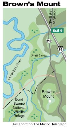
Brown’s Mount is a well known prominence jutting into the Ocmulgee River along its left (east) bank in southeastern Bibb County, Georgia (Fig. 1). The north-south trending summit of Brown’s Mount consists of a central conical hill with relatively flat areas to the north and south. The mount, comprised of shallow marine deposits, is capped with hard fossiliferous limestone that has helped protect the feature from erosion. While the bedrock of Brown’s Mount was deposited many millions of years ago, the stepped ridges radiating around the flanks were sculpted during the Quaternary and probably range in age from tens- to hundreds-of-thousands of years old. The descending ridges around Brown’s Mount characteristically consist of “treads and risers” much like a stairway. The “treads” are a sequence of ancient terrace levels separated by the “risers,” the eroded scarps between the ancient terrace levels.
The three soils mantling the bedrock on, respectively, the Brown’s Mount summit, slopes, and flanking ridges are Ultisols formed in sandy parent materials. Orangeburg sandy loam (OcB; a Fine-loamy, siliceous, thermic Typic Paleudult) occupies the flat to gently sloping summit of the mount. Vaucluse loamy sand (VeD; a Fine-loamy, siliceous, thermic Typic Fragiudult) is present on the steep upper sideslopes but is discontinuous among the outcropping bedrock. Ailey loamy sand (AgB; a Loamy, siliceous, thermic Arenic Fragiudult) is found on the moderately sloping lower sideslopes and moderately to gently sloping stepped ridges along the northern and eastern flanks (Woods 1979: Sheets 14 and 19). The anticipated stratigraphy of prehistoric component occupation surfaces (COS) in the unplowed and uneroded Ultisols is as follows: present or zero years ago = soil surface; Late Woodland stage (about 1000 years ago) » upper E horizon; Late Archaic stage (about 4000 years ago) » transition from E to BE horizon; Late PaleoIndian/early Early Archaic stage (about 9000 years ago) » transition from BE to Bt horizon; and early PaleoIndian stage (about 11,500 years ago) » upper Bt horizon. Woods (1979:40) presents a profile description of a typical pedon of Orangeburg sandy loam that has been plowed, eroded and the profile significantly truncated. In this example of an Orangeburg profile, the only surviving archeologically-relevant horizons below the Ap (plowzone, 0-20 cm) are the truncated B1 (BE, 20-36 cm) and B21t (Bt1, 36-76 cm) horizons. The profile description of a typical pedon of Vaucluse loamy sand is unplowed and retains the full complement of archeologically relevant soil horizons: A1 (A, 0-13 cm); A2 (E, 13-20 cm); B1(BE, 20-33 cm); and B2t (Bt, 33-58 cm) (Woods 1979:41). The profile description of a typical pedon of Ailey loamy sand is plowed but apparently only modestly eroded. The archeologically relevant soils horizons surviving below the Ap (0-20 cm) are: a moderately truncated A2 (E, 20-76 cm); B1 (BE, 76-102 cm); and B2t (Bt, 102-127 cm) (Woods 1979:35-36). The expected profile preservation on the diverse upland landscape positions of Brown’s Mount ranges from severely eroded and truncated with little potential for the preservation of undisturbed component occupation surfaces, to very modestly truncated with a very high potential for the preservation of undisturbed prehistoric component occupation surfaces.
Lowlands
The low-lying landscape along the Ocmulgee River consists of at least two major terraces. Based on the results of the 1996 testing at the Lamar Mounds site (Williams 1997), the silty alluvial deposits of the oldest terrace (T-2) probably began accumulating during the terminal Wisconsinan to initial Holocene Stage and continued until the late Holocene some two to three thousand years ago. At that time, the Ocmulgee River entrenched its channel and began developing a new, slightly lower floodplain (T-1). The thick accumulations of historic alluvium have masked much of the bottomland landscape rendering it difficult to distinguish these terraces from surface indications.
The two most commonly mapped soils in the bottomlands provide some information about the age of the terraces (Woods 1979: Sheets 14 and 19). The soils of the older terrace are mapped as the Chewacla association (CK; a Fine-loamy, mixed, thermic Fluvaquentic Dystrochrept). The somewhat poorly drained Chewacla soil is an Inceptisol indicating that a significant interval of prehistoric time elapsed in which the landform received no meaningful quantity of alluvial sediment and soil development could occur. However, during the historic period a blanket of historic or Post (Euro-American) Settlement Alluvium (PSA) from a few centimeters to over one meter thick generally buries this soil. PSA continues to accumulate and, consequently, often retains stratigraphy and typically lacks evidence of soil development. The other major soil mapped in the bottomlands is Congaree silt loam (Co; a Fine-loamy, mixed, nonacid, thermic Typic Udifluvent). The well drained or moderately well drained Congaree soil is an Entisol formed in PSA greater than sixty-five inches (1.65 m) thick. This soil is most typically present on the modern floodplain adjacent to the river channel, but also occurs in some backswamp areas of the floodplain.
ANALYSES OF EXISTING DATA
Cultural Components
The previous researchers at Brown’s Mount have strongly (perhaps overly) emphasized the Macon Plateau component and downplayed the cultural components of the previous 8000 or more years that are present at the site. For example, Williams (1993:62) notes that a single plain fiber tempered sherd of Late Archaic manufacture had been found during the 1935 excavations. “This is not included in any of the following analysis tables, and the sherd seems strangely out of context here at Brown’s Mount.” Williams (1993:62) also notes that “there were a few sherds associated with other cultures found at Brown’s Mount.” He goes on to observe that “these sherds are of types known to occur in central Georgia during the Late Woodland period, and it seems quite probable that they are directly associated with the Macon Plateau occupation of the site.”
Williams (1993:64) states that eight projectile points were recovered during the 1935 excavations at Brown’s Mount but only seven are identified. The identified projectile point types include: a Dalton Point (Late Paleoindian period); a Big Sandy side-notched point (Early Archaic period); a Palmer point (Early Archaic period); two Savanna River points (Late Archaic period); and two Hamilton points (Late Woodland). Williams (1993:70) notes that “diagnostic PPKs” (projectile points/knives) are rare surface finds due to their continual collection. Yet during his limited 1991 investigation at Brown’s Mount Williams’ survey recovered a Dalton point “at the northeastern end of the mount.”
In addition to the prehistoric Native American cultural material recovered from Brown’s Mount, nineteenth century Euro-American cultural material has also been recovered. As Williams (1993:65) notes, “It appears that somewhere in this area was an early nineteenth century homestead, one of the first on Brown’s Mount.”
Stratigraphic Distribution
Spatial Distribution
Preliminary Conclusions
In the section entitled “An Archaeological Program for the Future,” Williams (1993:75) proposes several tasks be accomplished at Brown’s Mount as part of the overall preservation program and prior to any future archeological investigations.
There is still a great deal of basic information about the site that needs to be gathered. Probably the first thing that should be done is the production of a new very accurate map of the summit of the site. This should include all the existing roads, field boundaries, and elevations on the summit itself. As part of this mapping process, a series of permanent concrete markers should be placed over the summit as future mapping reference points. In this way both currently known and future archaeological resources can be accurately mapped with reference to one another. Once an accurate map of the summit is in hand, a series of systematic test excavations, perhaps shovel tests, should be made over the entire summit to obtain a better assessment of the differential distribution of the archaeological materials over the surface of the mount. It is known that these materials are very thinly scattered, and traditional shovel tests may not yield adequate samples. In this case, more controlled surface collections should be made at regular intervals on the roads and other exposed area on the summit. All of this information should be collated through the museum staff of the Museum of Art and Science in Macon.
The need for a systematic three-dimensional survey that is tied to an accurate, detailed map is paramount for adequately defining the soil stratigraphy of the components and their condition. Thus the goal of the proposed work is to conduct an inventory of the cultural resources present at Brown’s Mount.
METHODOLOGY
The purpose of the proposed study is to collect and analyze sufficient data so that the location, stratigraphy, characteristics, scientific values, and condition of archeological resources and threats to them can be determined. It is proposed that the Brown’s Mount property owned by the Museum of Arts and Sciences (the Museum) be subjected to an intensive archeological survey to locate cultural materials, identify the cultural components present, and define the context of both historic and prehistoric sites. The purposes of this survey include: (1) establish permanent datums on the property, perform a detailed land survey, and create a detailed topographic map of the Brown’s Mount property; (2) perform an intense subsurface archeological survey to inventory all the historic and prehistoric cultural resources, both known and as yet undiscovered, of all of the property owned by the Museum at Brown’s Mount; (3) accurately document the spatial and stratigraphic context of those cultural resources; (4) identify the age/cultural of the individual components based on diagnostics and/or stratigraphic context; (5) evaluate the need for more intensive studies (i.e., evaluation of site significance); and (6) develop a cultural resource management plan for the Brown’s Mount property. All of the data (cultural materials and field notes) shall be thoroughly analyzed and a detailed report prepared. The following sections detail the activities, techniques and methodologies that shall be followed at each stage of the investigations.
Gridding
The first step of the investigations of Browns Mount shall involve establishing a 20 meter interval grid oriented to the cardinal directions over the entire tract. An attempt will be made to link this grid to the 1000-meter interval Universal Transverse Mercator (UTM). This linkage will facilitate the eventual inclusion of the data into a park geographic information system (GIS). A transit shall be used to orient and align the transects of the grid, and a metric tape shall be used to measure the 20 m interval along each transect. The grid shall be marked at each 20 m interval with a pin flag marked with the position coordinate. A transit and stadia rod shall be used to map the grid points, including the elevations, recent features, and other details of Browns Mount. The grid will serve as the reference system for the following stages of investigations.
Controlled Surface Collection
A controlled surface collection is the first stage of defining spatial and stratigraphic variation of cultural materials across Browns Mount. Each square of the 20 m interval grid established in Browns Mount, referenced by the grid coordinate of the square’s southwest corner, shall serve as the basic surface collection unit. All cultural material shall be collected from the square’s surface into a bag labeled with the following information: (a) project designation; (b) collection square’s designation; (c) stratigraphic provenience (surface) ; (d) date of collection; and (e) collector. Following the laboratory processing and cataloging of the surface collected cultural material, artifact density analysis shall be performed. Analysis of the spatial distribution of various artifact classes shall also be performed.
Controlled Subsurface Survey
The field techniques employed during typical archeological surveys do not consider soil stratigraphy or the stratigraphic potential of the landscape. From a theoretical perspective, the “safest” approach to archeological surveying is to employ a technique and methodology that will test the following three related assumptions: (a) all the soils and deposits of a survey area have the potential to contain buried occupational surfaces, artifacts, and features of cultural components; (b) all prehistoric cultural components are (or were) buried and stratified in the soil or geological deposit; and (c) the cultural components of a specific time period are associated with a specific soil horizon and/or geological deposit.
The controlled subsurface survey of Browns Mount shall follow the archeological postholing methodology presented by Abbott and Neidig (1993). The tests shall be conducted on the established 20 meter interval grid. The postholing technique employs a calibrated scissors postholer that excavates a 15 cm diameter cylindrical hole. In unplowed soils the posthole test shall proceed by removing successive 10 cm thick soil samples from the profile. If the soil profile has been plowed, the Ap horizon (plowzone) should be treated as a single stratigraphic unit regardless of its total thickness though it still may be convenient to process 10 cm levels of a thick Ap. The thickness of the Ap horizon is often a multiple of 10 cm but may be slightly thinner or thicker. If the soil profile has been mantled by a layer of fill, the fill layer shall be excavated as if it is an Ap horizon. Once the Ap horizon or fill layer is removed from the posthole test, the 10 cm excavation interval (relative to the surface) shall be reestablished and continued for the remainder of the test. All items collected from the Ap horizon or the fill layer shall be bagged together and the depth range recorded (e.g. Ap 0-26 cm).
Each extracted soil sample of each excavation level shall be inspected and briefly described (soil sample texture(s) and Munsellâ color(s)) prior to screening through ¼ inch (6.35 mm) mesh hardware cloth. The items left in the screen, the residuals1, shall be collected and placed in an appropriately labeled excavation level bag for that posthole test. Each level bag shall be labeled with the following information: (a) project designation; (b) site or field number; (c) posthole test designation; (d) depth range of excavation level; (e) date of excavation; and (f) excavator. For those posthole tests with definite cultural material, the soil profile descriptions shall include the horizon(s) transitions and the appropriate soil profile designation(s). To aid record keeping and tracking of the bagged residuals, residual counts of each excavation level shall also be recorded on the profile form. The actual depth of the individual posthole test will usually vary, but the relative depth penetrated by the posthole test shall be the similar. All of the posthole tests shall be dug through the surface soil horizons, including any fill layers, and shall penetrate minimally two full excavation levels into the Bt horizon of the soil. If cultural material is encountered in the Bt horizon, excavation of the posthole test shall continue; excavation will be concluded only when two consecutive sterile excavation levels have been removed from the Bt horizon.
Following the laboratory processing and cataloging of the cultural material derived from the subsurface survey, stratigraphic analyses shall be performed. If occupation surfaces are identified in undisturbed contexts, artifact density analyses of those buried occupational surfaces shall be performed. An artifact density analysis shall also be performed on the cultural material from the disturbed portion of the soil. Analysis of the spatial distribution of various artifact classes shall also be performed for the disturbed portion of the soil and any identified buried occupational surfaces.
Controlled Subsurface Intrasite Survey
The controlled subsurface intrasite survey is limited to those site(s) defined during the controlled subsurface survey that appear to still contain undisturbed cultural material. This phase of the subsurface survey shall focus on further defining the spatial and stratigraphic context(s) of the buried occupational surfaces. This shall be done by restricting the grid across the area to be investigated to a 10 m interval. The excavation techniques and methods are the same as those of the controlled subsurface.
Following the laboratory processing and cataloging of the cultural material derived from the subsurface intrasite survey, stratigraphic analyses shall be performed incorporating data from the earlier subsurface survey. Artifact density analyses shall be performed for those buried occupational surfaces. Analysis of the spatial distribution of various artifact classes shall also be performed for the identified buried occupational surfaces.
LABORATORY ANALYSES
Artifact Processing. All artifacts shall be processed, cataloged, analyzed, and prepared for permanent curation in accordance with 36 CFR Parts 79 and 800. The Principal Investigator (PI) and the volunteer crew will analyze (e.g., age, material, frequency, weight, and function), catalog, and prepare for curation all recovered artifacts and floral and faunal samples. The PI and volunteer crew will process (e.g., floatation) all feature fill samples, and analyze (e.g., age, material, frequency, weight, and function), catalog and prepare for curation all recovered artifacts and floral and faunal samples. A detailed attribute analysis (e.g., measurements of tool elements, thickness of sherds, etc.) will be performed for all diagnostic artifacts. The results of these attribute analyses will be tabulated and presented in the site report. The ceramic assemblage will be tabulated by category based upon the surface decoration or treatment, and further subdivided into temper type and vessel element (e.g., base, rim, body sherd, etc.) represented. Sherd internal paste color will be recorded using standardized Munsellâ color values. With the approval of the Robins AFB historic preservation officer, certain classes of collected materials (e.g., fire-cracked rock) may be discarded following analysis, tabulation and inclusion in the artifact data base. The discarded materials will also be described and their tabulations included in the site report, and noted in the PI’s log. Applicable analytical or investigative techniques may include ceramic and/or lithic material sourcing, pollen analysis, carbon 14 or other dating method, and sediment (soils) analysis. Analysis of prehistoric and historic cultural materials will be compatible with artifact typologies and nomenclature for the Southeast region, and consistent with the descriptions and classifications presented in Georgia Archaeological Research Design Papers (GARD Papers).
Artifact Cataloging. The artifacts and other materials collected will be cataloged as per the SEAC CATALOG MANUAL FOR ARCHEOLOGICAL OBJECTS, Vol. 1-3, published by the National Park Service, Southeast Archeological Center (SEAC), Tallahassee, Florida. The artifacts inventory will be entered into the Automated National Cataloging System program (ANCS V. 3.31) at Ocmulgee National Monument. A copy of the completed database will be delivered on 3.5” DOS formatted diskette(s) to SEAC.
Collection Preparation and Submission. The artifacts and other materials will be cleaned and labeled, and the artifacts and all documentation relating to the collections (field notes, logs, lab notes, analysis forms, photographs, etc.) prepared for curation as per the guidelines presented in Appendix I: Standards for Submission of Archeological Materials. Upon completion of this project the collection and all documentation relating to the collections will be reviewed by the Ocmulgee National Monument Cultural Resources Management Specialist prior to acceptance. Upon approval of both, all materials shall be curated and all documentation archived at Ocmulgee National Monument, Macon, Georgia.
REPORT
A draft report shall be prepared presenting the results of the investigations at Brown’s Mount. The report shall present the study results both graphically and narratively; an appendix detailing the results of the individual subsurface tests shall be included. The graphically presented results shall include: a detailed topographic map of the property showing the site locations; an artifact density map(s) of each site illustrating the spatial distribution of artifacts; fence diagrams showing the soil stratigraphy and the context of the associated cultural materials of each site; and other graphics as needed to present pertinent information. The narrative portion of the report shall include but be not limited to: suggested criteria for the evaluation of each site’s significance; suggestions for the selection of various sites to be tested in order to evaluate them for National Register eligibility; and the development of a cultural resource management plan for the Brown’s Mount property. The draft report shall be forwarded to SHPO and the State Archeologist for review and comments. Based upon the comments received, final report shall be prepared presenting the results of all the investigations. Copies of the final report shall be archived at the Museum and Ocmulgee National Monument, and sent to SEAC, SHPO, the State Archeologist, and the Museum of Aviation .
The Final Report will contain a table of contents, index, and include, but not be limited to, the following sections written in English:
REFERENCES CITED
Abbott, Larry R., and Craig A. Neidig 1993 Archaeological postholing: A proposed subsurface survey and site-testing methodology. In: Highways to the Past; Thomas E. Emerson, Andrew C. Fortier, and Dale L. McElrath, Eds. Illinois Archaeology 5:38-45.
Marshall, Richard A. 1971 An unusual house at the Brown’s Mountain site. Newsletter of the Southeastern Archaeological Conference Bulletin 10(2):24-25.
Salter, Sallye 1960 Macon Archaeologists Spend Year Excavating Indian Log Town House at Brown’s Mount. The Macon News. June 7, 1960.
Williams, Mark 1993 The View from Above: Archaeological Excavations at Brown’s Mount. Lamar Institute Publication 23.
Woods, John C. 1979 Soil Survey of Bibb County, Georgia. USDA-SCS.
APPENDIX I
Standards for Submission of Archeological Materials
This document outlines a series of minimum standards for the processing and curation of archeological collections recovered by the National Park Service archeologists conducting work at Robins AFB. The goal of these standards is to ensure that collections will be properly processed, documented and managed in accordance with 36 CFR 79 and 800 and National Park Service standards.
The Contractor will be responsible for consulting with the Robins AFB Contracting Officer’s Representative (COR) in the early stages of the project regarding installation-specific curation requirements. The COR technical representative will provide technical advice and assistance in obtaining proper archival quality materials.
The following is a list of standards for the processing and storage preparation required prior to the permanent curation of both prehistoric and historic archeological collections. The standards have been divided into three major categories: (A) General; (B) Artifacts; and (C) Records.
When a collection is turned over to Museum of Aviation at Robins AFB, an unbound inventory of all the associated components shall accompany the collection. The inventory shall be submitted on 8½” x 11” archival bond (acid-free) paper and contain the following information:
3. Artifacts illustrated or photographed for print should be labeled as such.
1 Residuals includes definite, probable, and possible cultural materials and pebbles. |
|
|